Tuesday, August 30, 2011

Show Low 8/9-30 mon/tue

Mon/Tue 8/29-30
Off to Show Low sunday afternoon after work (@ 2hr drive). Arrived at TJ's condo, 5pm, for quick dinner. Then  off with Andy, TJ to Chuck/Bill  place (community hall) to play cards including Donna.
Monday:
After a nice breakfast we (andy,TJ, & me) headed out to look at some Park Models in Venture Inn park. Great buys. Then we picked up Bill/Chuck for some sightseeing. Took TJ & andy back to condo and B/C & I headed to Lakeside/Pinetop for some geocaching. Hiked on the Woodland lake park trail. Down into a canyon. All kinds of wild flowers along the creek. Dropped off Bill/chuck. Later, they came over to the condo for a game of Mexican train.
Tuesday:
We all met at Denney's for breakfast.  Andy left ofr Goodyear/Phx at 1030am. I me up with bill/chuck later to do some geocaching. Hiking in a area call Big springs where the wild birds are protected. We called  to meet us for a late lunch at tall Pine cafe (2pm). Awesome hamburgers. Then walked to the movie to see "Conan".   Said my good byes and headed back to MC. Arrived @8pm.


Memorial park

yes the geocache/bison tube hanging


Tuesday, August 23, 2011

Marshall Lake 8/23

Tuesday 8/23   geocaching at Marshall Lake out of Flagstaff.
Faith  (co-worker) and I worked on this geocache Puzzle.   See below.  The name was "Count the Spheres".  You had to turn these symbols into Co-ord's.  Which is 05.996  32.210 Symbols are planets.
We headed out  to Flagstaff then onto Lake Mary road turning onto forest service rd 128 which takes you up the mountain to Marshall lake.  After our find we did some more geocaches in the area. Then a stop at Windy''s for a bite to eat.  Time 3:30p - 7pm  When we arrived at the RV park it started to rain very hard.

geocache puzzle

Log sheet at cache

Faith & me at cache site

another cache site: no its there or there  :)

Marshall lake (its a dry lake now

Sign here by

Monday, August 22, 2011

Geocaching/William 8/22

Monday 8/22/11
The four of us (kathy/derek & kim) took off for Williams from Meteor Crater.  Our first stop was in Parks off of I-40.  The geocache was near a old water pump house on the old Rt66 road which is no longer used.  From here off to Hwy 64 whlich is the road to the Grand Canyon but we headed to a
airport for four geocaches.   Into Williams for lunch.  Off again to Dogtown lake which is a great area for camping.  Lots of geocaches and some good hikes.  Back to RV park around 7pm  Fun day.


old water pump house Rt66

Old Rt 66 used in the 40's


Hike up hill-great views

at top

geocaching off of Hwy 64

In Williams

In Dogtown lake area

Thursday, August 11, 2011

Future look for Meteor Crater Vistor Ctr

The first picture is the current look at the Visitor Center where I work.  The Board of Directors voted on the new look.  Project is estimated to take about 5-8 years.   Also the current picnic area will be enclosed for the eating area, new restrooms,etc   Great ideas for many things to happen here.
current view of Visitor Ctr

New entrance to Center

Addimision area, all enclosed

Inside.

Tuesday, August 9, 2011

Bellemont tue 8/9

tuesday  8/9
Had to do the following:  Jeep to dealer, back side window  doesn't work. Made an appointment for next wed for estimate. Then had tires rotated. Oil change. windsheild on jeep repaired. Busy day. But was able to squeeze in two geocaches in town which were first-to-find.  Then headed north on I-40 to Bellemont where co-workers Bunny/Jim & Faith/Paul  had their campsite about 4 mi into the forest. I was invited for the BBQ. Of course had to stop for a geocache near by. After dinner we did dessert call "wadingers".  Using a stick,  put on some  croissant dough, shaping it on.  Then bake it over a campfile bed of coals.  When done, fill shell with pie filling or??? Fun and  tasty.  Back at RV aroung 9:30p.

geocache near camp site

moooooo

looks tasty

Faith & Paul doing the BBQ


wadinger- getting to put over coals

Monday, August 8, 2011

Schnebly Road to Sedona 8/8

Monday 8/8
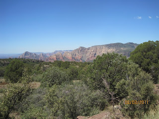
We (Kathy/Derek, Kim)left the RV park at 9am.  Headed to Flagstaff & south on I-17. Taking exit 320 schnebly Hill road. Its a 12 mi dirt road to Sedona. The first 6mi is smooth to the Vista point. Stopping for a couple of geocaches. Arrived at the Vista with great views of Sedona Mtns. The Vista is also the stopping point for all jeep tours like Pink Jeep before heading back down the mountain which is another 6 mi on a very bumpy rocky road. At the Vista we placed a New Geocache from us. We then headed down the hill, stopping for more geocaches.  Finally arrived at base around 2pm. Quick stop at Burger King then onto Flagstaff for the movie -Planet of the Apes.  Good One.  Back at RV park around 7pm. Fun day.


Flagstaff  1st stop: Derek finding geocache

Schnebly road to Sedona

Locating geocache off of road

schnebly rd

still on Schnebly rd to Vista


kathy/derek at Vista pt

Kim

Me

view from Vista


Placed new geocache under tree


Going down mtn

rocky rd going down but not bad

great views

Derek & I walked out to get this geocache. Just kidding here


Locating another geocache

called Bat rock

The end.